| |
WAITING FOR THE
SHADOW
SOLAR AND LUNAR ECLIPSE OBSERVINGFUTURE EXPEDITION & EVENT PLANNING |
|
|
|
|
|
|
|
|
|
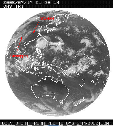
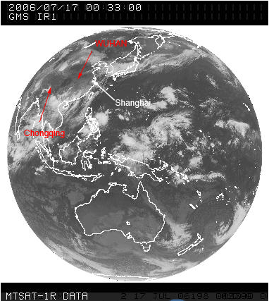
Monsoonal Cloud Movements over South East Asia
In attempting to familiarize myself with weather patterns and cloud movements over China in July, I've created a series of animations to visualize it more easily. Cloud photos are courtesy of the Australian Bureau of Meteorology. This page began life as a review, planning and self education tool. The notes were not originally intended for public consumption. As such the opinions expressed are those of Joe Cali and not the Australian Bureau of Meteorology nor the Australian National University, Research School of Earth Sciences. It is the readers responsibility to review all opinions on the weather and form their own observing strategy and I take no responsibilty for missed opportunities that result from reading opinions expressed on this page.
YEAR |
|
|
2004 |
 |
 |
|
2004 July 17-July
27 : 10 day window centred around eclipse day http://www.bom.gov.au |
2004
July 17-July 27 : 10 day window centred around eclipse day http://www.bom.gov.au |
|
2005 |
 |
 |
|
2005
July 17-July 27 : 10 day window centred around eclipse day http://www.bom.gov.au |
2005 July 17-July 27
: 10 day window centred around eclipse day http://www.bom.gov.au |
|
2006 |
 |
 |
|
2006
July 17-July 27 : 10 day window centred around eclipse day http://www.bom.gov.au |
2006 July 17-July 27
: 10 day window centred around eclipse day http://www.bom.gov.au |
|
2007 |
 |
 |
|
2007 July 17-July
27 : 10 day window centred around eclipse day http://www.bom.gov.au |
2007 July 17-July
27 : 10 day window centred around eclipse day http://www.bom.gov.au |
|
2008 |
 |
 |
|
2008 July 17-July 27 : 10
day window centred around eclipse day http://www.bom.gov.au |
2008 July 17-July 27 : 10
day window centred around eclipse day http://www.bom.gov.au |
|
Follow the animation and look
carefully:
Note :
It is frequently clear in the area south of Shanghai when at the
same time, it is quite cloudy at inland sites like Wuhan.
Shanghai appears to be located in, for want of a better word,
a cloud shadow.
There are very few days in any of the July 17-27 animations for
the years 2004,-2008 where
it is clear inland while being cloudy in Shanghai. There are few
tropical storms in the survey period.
I'd therefore conclude that while the chasers in Wuhan and other
inland sites might want to run to Shanghai/Jinshan it is unlikely
that Shanghai observers will gain any benefit from running inland
except in the case of a tropical storm.
|
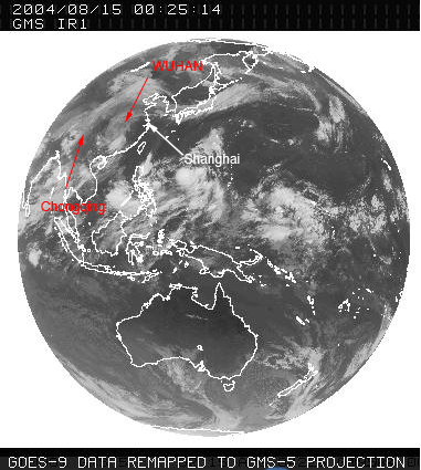
All satellite images on this page are courtesy of and © Copyright Commonwealth of Australia 2009, Bureau of Meteorology (ABN 92 637 533 532) http://www.bom.gov.au |
|
2004 August 16-31
: 15 day window showing ingress of tropical storms on Shanghai
coast. Note that they all originate over the ocean just off the NE coast of the Philippines. Storms that form anywhere north of this area might seem to run towards Shanghai but cross the coast north of Shanghai. Some examples of these are present in the six July 17-27 animations. From formation, storms take 3-6 days to reach the Shanghai coast. Large tropical storms are generated by anomalously warm waters. In the weeks leading up to TSE 2009 I'll monitor the SST(Sea Surface Temperature) anomoly data for the ocean off the NE coast of the Philippines. If possible, I'll post the info here. |
|
Analysis of cloud cover at the time of totality. The presence of cloud cover on such low resolution images is difficult to determine absolutely. However I think this analysis makes a contribution to the overall picture of weather prospects.
|
|
|
|
|
|
|
|
|
|
|
|
|
|
|
|
|
|
|
|
|
|
|
|
|
|
|
|
|
|
|
|
|
|
|
|
|
|
|
|
|
|
|
|
If we look at completely clear skies, then Shanghai is dramatically better than Wuhan in 3/5 years, equal in one and worse in one year. Looking at scattered cloud data, Shanghai is slightly better in 3 years, equal in one year and slightly worse in one year. Looking at the data paying attention to relative conditions 1. When it is cloudy in Shanghai, it's usually cloudy inland. 2006 is the exception to this (see note 4) 2. When it is cloudy inland, it is frequently clear in Shanghai 3. When a cyclonic tropical storm hits Shanghai, the cloud breaks up the day after landfall. 4. When a cyclonic tropical storm hits Shanghai, it can push the cloud back away from Wuhan. 5. There are few if any tropical storms present in the July 17-27 data sets. 6. Chances of an eclipse being visible in very clear skies is greater in Shanghai that Wuhan. 7. Chances of seeing an eclipse through broken cloud is more similar for Shanghai and Wuhan
Possible Strategy Hang back in Shanghai and watch the weather until July 20th. Go to Jinshan, Hangzhou or Yanshan Harbour in all cases except if there is an incoming cyclonic tropical storm. In order for a tropical stom to hit the Shanghai coast, it most likely will originate close to and NE of the Phillipines. If there is a cyclonic storm, guess when it will make landfall. If it will land 1-2 days before the eclipse, the cloud will probably break so go to Jinshan regardless. If we think the storm will land the day of the eclipse, go to Wuhan ifwe think the inland trough will be pushed west of Wuhan otherwise, we're probably still better off staying on the coast & staying mobile.
|