The Google Earth Polar Alignment Method
by Joseph Cali
If you know exactly where you will be setting up your gear you can use
Google Earth (not Google Maps) to align your mount even during the
daytime. I tried this one afternoon last week. Sky was predicted to
clear at 2am and I wanted to photograph the Kreutz comet 2020 X3
(ultimately unsuccessful) at 4am low on the southeast horizon if it was
bright enough. My front deck is floored in slightly bouncy thick-sheet
(fibre-cement sheeting) however the concrete landing at the top of the
stairs with open sky overhead is 4" solid concrete topped on a brick
staircase structure. Quite solid! It also gave me a clear view to that
horizon.
First step was to launch Google Earth (GE), find my house, and activate
the ruler tool. Google Maps does not have this ruler tool which is why
GE is used. I started the ruler right at the landing and drew a line
due south 180 degrees until it intersected with some landmarks that
were easily recognisable. The edge of a small shed on an adjacent
property some 150m away was precisely due south. This method is
independent of magnetic interference. My house is all steel
construction, cladding, roof and structural components for termite
resistance and so any magnetic method won't work.

Note: I am in Australia, the southern hemisphere, obviously in the
northern hemisphere you point north. If however, there is a convenient
landmark in the opposite direction to your pole, you can always align
the mount simply by aligning and looking from the opposite direction
but the polar axis must always point to your pole.
I set up my EM200 mount and aligned the straight edge of the mount with
the gap between the two shed buildings and exactly on the edge of the
smaller shed on my neighbour’s property. This task is even easier with
a small tracker if the tracker has a polar finder. If you have
something like a Polarie and no polar finder, you could use the long
straight rear casing and align them on something due east or due west.
If the landmark doesn't precisely align, consider changing your
telescope / tracker location so that you have a precise N, S, E, W
reference.
After setting the azimuth, I used a clinometer app on my iPhone to set
the polar axis elevation to my latitude. After dark, I checked using
the polar finder and I was almost exactly on the south pole. So close
that I didn't bother to adjust.
Using ground structures
Another variation of this method is if you have a driveway or other
ground structure visible on GE, you can measure the orientation of the
structure on GE then cut yourself a triangular template with the angle
between that feature and due south or north. Place the template against
the side of your mount and align the other edge with the driveway edge.
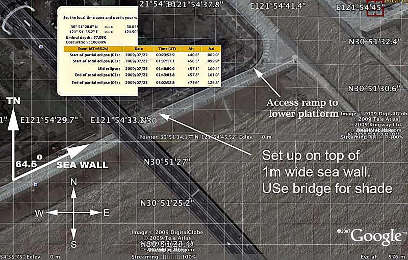
I first devised this technique when observing a total solar eclipse
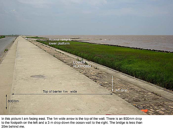
from near Shanghai in 2009. We set up on a long straight concrete sea
tidal / storm wall near the Donghai Bridge south of Shanghai which we
had scouted and selected prior to arrival in China using Google Earth
and Google Maps street view.

The site looked good. Sitting & set up on the seawall, it was
unlikely anyone would be able to stand in front of us. We were sure the
massive concrete structure and the nearby bridge would have a lot of
steel reinforcing causing problems with compasses.

Using the triangular template, the polar axes could be set at 64.5 deg
to the wall. There were four mounts in our group requiring alignment.
Using the template and a clinometer, I worked my way around each member
of the group and used the template technique, new to everybody to align
all four mounts over a period of 15 mins. Being able to sight along a
very long length of the wall cancelled out any small variations in the
alignment of the wall.

These methods can be applied equally well to a location you are very
familiar with, to one that you have never visited and scout from the
web beforehand.
--


