WAITING FOR THE SHADOW

SOLAR AND LUNAR ECLIPSE OBSERVING

HOME PAGE

ABOUT

CONTACT

PAST ECLIPSES

FUTURE ECLIPSES

 OTHER EVENTS

 ECLIPSE PRIMER

ECLIPSES AUSTRALIA

 LINKS

 
"Eclipse on Top of the World"
The March 20, 2015, Total Solar Eclipse
Content of these pages and more is available as a downloadable PDF.....click here to DOWNLOAD [13.5MB file]
Apology to site visitors : I accidentally placed a broken link to the above document. Too late but it is now correct.  


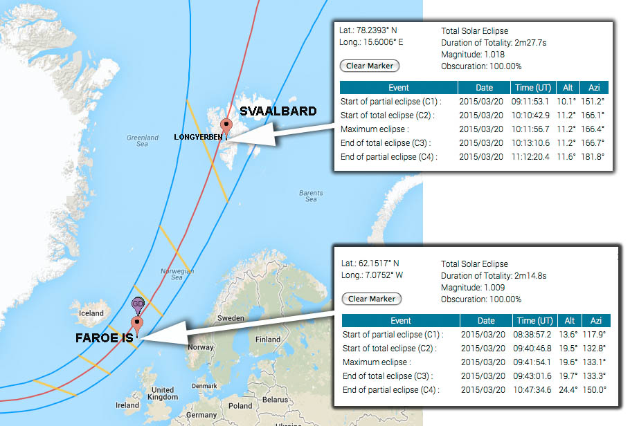
On March 20th, 2015 a total eclipse of the Sun will be visible from a swathe of the Arctic Ocean. The path of totality only makes landfall on two island groups, Faroe Islands and Svalbard.

Prior to each solar eclipse since 2008, I have produced a collection of local circumstances and other relevant information for the eclipse as seen from my chosen observing location.  Since 2010, I have collated this into a printable observer’s almanac or handbook that incorporates blank pages that can be used as a trip diary or for planning or recording observations. The travel diary has several pages for March 20th so that an account of the eclipse can be written up in detail for that day.  This year I've decided to release the data or graphics as a web page.  The data used to produce this publication is drawn from many on-line resources listed with each resource.  


The path of totality of the eclipse will only cross two land masses.  The Faroe Islands, a Danish Territory located due north of Scotland and Svaalbard, a Fjord studded island located halfway between the north coast of Norway and the North Pole.

Situated in the heart of th­­­­­­e Gulf Stream in the North Atlantic at 62°00’N, the Fa­r­oe Islands lie n­­­­orthwest of Scotland and halfway be­tween Iceland and Nor­­way. The archipelago is compos­ed of 18 islands cover­ing 1399 km2 (545.3 sq.­miles).  The weather is maritime and quite changeable, from mo­ments of brilliant sun­shine to misty hill fog, to showers. The Gulf Stream encircling the islands tem­pers the climate. The har­bours never freeze and the temperature in winter time is very mod­erate consi­der­ing the high latitude. The population is 48,193 (1st February 2013). About 19,900 people li­v­­­­­­e­ in the metro­politan area which com­­­prises Tórs­­havn, Kirkjubøur, Velba­staður, Nólsoy, Hestur, Kolt­ur, Hoyvík, Argir, Kald­bak, Kaldbaksbotnur,  Norð­radalur, Syðradalur,  Hvít­a­nes, Sund, Kolla­fjørð­ur, Signabøur and Oyra­reingir, while about 4,600 people live in Klaks­vík, the s­e­c­­o­­nd lar­gest town in the Faroe Islands.  
(Source:  http://www.faroeislands.com/default.aspx?pageid=9706&sectionid=295 )


Svalbard, formerly known by its Dutch name Spitsbergen, is a Norwegian archipelago in the Arctic Ocean. Situated north of mainland Europe, it is about midway between continental Norway and the North Pole. The group of islands range from 74° to 81° north latitude, and from 10° to 35° east longitude.

The largest island is Spitsbergen, followed by Nordaustlandet and Edgeøya. Administratively, the archipelago is not part of any Norwegian county, but rather forms an unincorporated area administered by a state-appointed governor. Since 2002, Svalbard's main settlement, Longyearbyen, has had an elected local government, somewhat similar to mainland municipalities. Other settlements include the Russian mining community of Barentsburg, the research station of Ny-Ålesund, and the mining outpost of Sveagruva. Svalbard is the northernmost place in the world with a permanent population.

The islands were first taken into use as a whaling base in the 17th and 18th centuries, after which they were abandoned. Coal mining started at the beginning of the 20th century, and several permanent communities were established.

I recommend you read more detail about the specific weather prospects of different observing locations by following links at the end of this article.  The "Executive Summary" is that both locations are more cloudy than we would like, ocean based cruises are likely to be very rough and the only guarantee of clear sky is to take one of the high altitude flights.  Of the two ground locations, Svalbard is colder but clearer than Faroe which is warmed by the Gulf Stream. The headline cloudiness figures Jay Anderson has come up with is that at eclipse time, mean cloudiness for Faroe is 75%(Vagar)-79%(Torshavn), Svalbard is 55% (Longyearbyen) to 70% (Barentsburg). I recommend you read the detail in Jay's report. Link at the end of this article.  
Svalbard offering opportunities for polar bears, artic wolves, arctic landscapes, aurorae and slightly better weather prospects for the eclipse and so the rest of this article is an observers almanac calculated for Svalbard.  
 (Source:  http://en.wikipedia.org/wiki/Svalbard )


Map credit : NASA/GoogleMaps


Introduction Sun/ Moon
Rise/ Set 
Sun Altitude
Eclipse Day
Orientation- corona
Sun's axis
EQ mount alignment
Sky at totality  Photographic Information Power & Batteries Further reading