WAITING FOR THE SHADOW

SOLAR AND LUNAR ECLIPSE OBSERVING

HOME PAGE

ABOUT

CONTACT

PAST ECLIPSES

FUTURE ECLIPSES

 OTHER EVENTS

 ECLIPSE PRIMER

ECLIPSES AUSTRALIA

 LINKS

"Eclipse on Top of the World"
The March 20, 2015, Total Solar Eclipse

Introduction Sun/ Moon
Rise/ Set 
Sun Altitude
Eclipse Day
Orientation- corona
Sun's axis
EQ mount alignment
Sky at totality  Photographic Information Power & Batteries Further reading


Altitude and Azimuth of the Sun and Moon on eclipse day
Observing locations


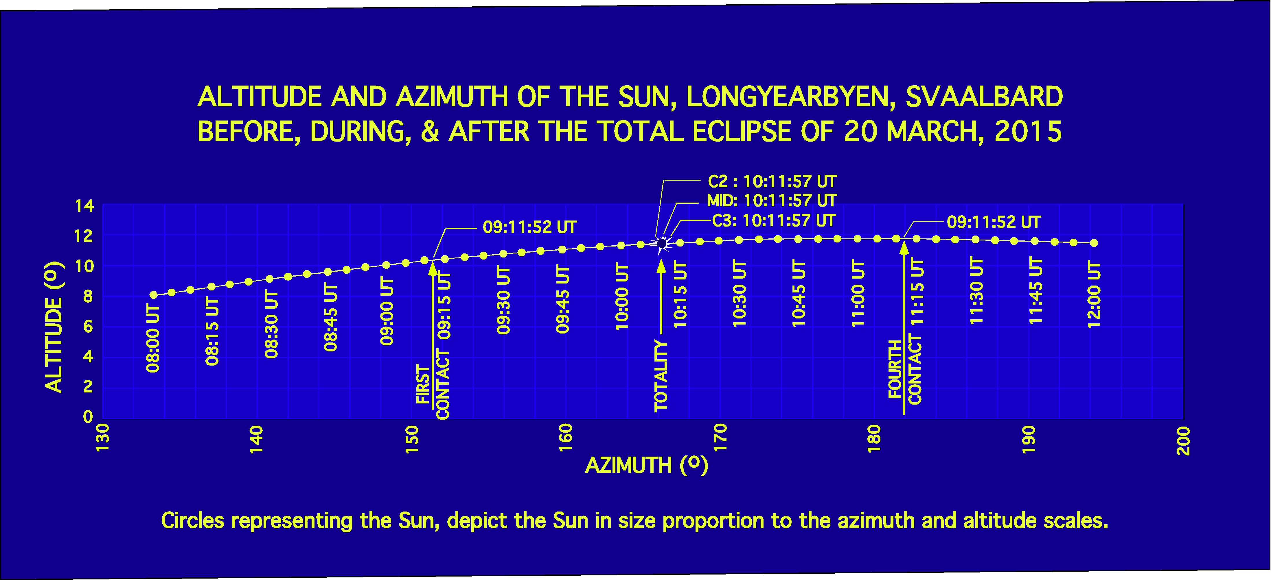
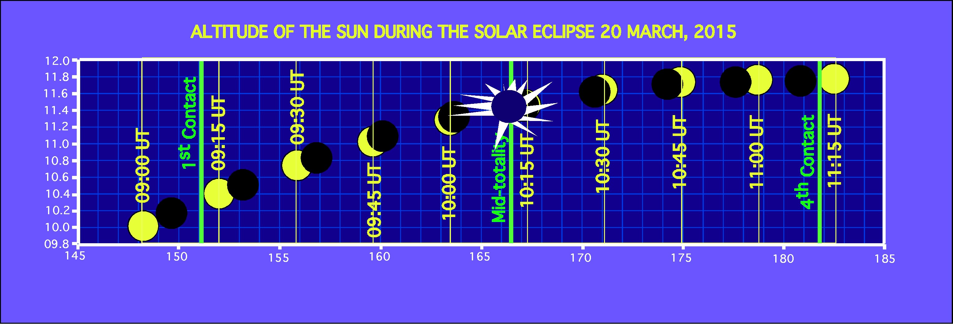
The same information, the azimuth and altitude of the sun on eclipse day is presented in a variety of graphical and tabular formats and at different time intervals.

Look carefuly some are presented in Universal Time (UT), some in local time UT+1hr.


ALTITUDE AND AZIMUTH DURING THE ECLIPSE - 15 min intervals

 Date        Time      Refraction    Azimuth      Altitude
               
20/03/14    08:00:00    00°06'32"    133°10'19"    8°05'05"
20/03/14    08:15:00    00°06'09"    136°55'18"    8°37'24"
20/03/14    08:30:00    00°05'50"    140°40'55"    9°07'35"
20/03/14    08:45:00    00°05'33"    144°27'09"    9°35'30"
20/03/14    09:00:00    00°05'20"    148°13'58"    10°00'58"
20/03/14    09:15:00    00°05'08"    152°01'22"    10°23'55"
20/03/14    09:30:00    00°04'59"    155°49'17"    10°44'12"
20/03/14    09:45:00    00°04'51"    159°37'41"    11°01'44"
20/03/14    10:00:00    00°04'45"    163°26'31"    11°16'26"
20/03/14    10:15:00    00°04'40"    167°15'41"    11°28'13"
20/03/14    10:30:00    00°04'36"    171°05'08"    11°37'03"
20/03/14    10:45:00    00°04'34"    174°54'48"    11°42'51"
20/03/14    11:00:00    00°04'33"    178°44'34"    11°45'38"
20/03/14    11:15:00    00°04'33"    182°34'23"    11°45'21"
20/03/14    11:30:00    00°04'34"    186°24'08"    11°42'01"
20/03/14    11:45:00    00°04'37"    190°13'46"    11°35'40"
20/03/14    12:00:00    00°04'41"    194°03'10"    11°26'18"


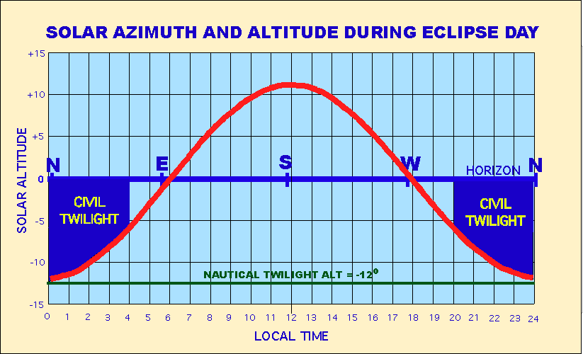
This graphic displays solar altitude over the full 24 hr period including time when it is below the horizon. Note that the Sun almost but never reaches the negative altitude of nautical twilight (-12o) and certainly not astronomical twilight (-18o).

"Morning civil twilight begins when the geometric center of the sun is 6° below the horizon (civil dawn) and ends at sunrise. Evening civil twilight begins at sunset and ends when the geometric center of the sun reaches 6° below the horizon (civil dusk). Civil twilight can also be described as the limit at which twilight illumination is sufficient, under clear weather conditions, for terrestrial objects to be clearly distinguished; at the beginning of morning civil twilight, or end of evening civil twilight, the horizon is clearly defined and the brightest stars are visible under clear atmospheric conditions.

The brightest planets can appear during this time. Venus, the brightest planet as observed from the Earth (see Apparent magnitude), is known as the "morning star" or "evening star" due to its visibility during civil twilight. There is enough light from the sun during this period that artificial sources of light may not be needed to carry on outdoor activities. This concept is sometimes enshrined in laws, for example, when drivers of automobiles must turn on their headlights (called lighting-up time in the UK); when pilots may exercise the rights to fly aircraft; restrictions on hunting; or if the crime of burglary is to be treated as nighttime burglary, which carries stiffer penalties in some jurisdictions. A fixed period (most commonly 20–30 minutes after sunset or before sunrise) is typically used in such statutes, rather than how many degrees the sun is below the horizon. The military initialisms BMCT (begin morning civil twilight, i.e. civil dawn) and EECT (end evening civil twilight, i.e. civil dusk) are used to refer to these periods." (Wikipedia)


ALTITUDE, AZIMUTH, RA, DEC OF THE SUN  EVERY HOUR DURING ECLIPSE DAY (Source: Starry Night Pro)

Local DATE  LOCAL Time AM/PM  AZI      ALT     RA      RA       DEC    DEC
DD/MM/YYYY  HH:MM:SS                           HRS     MIN      DEG    MIN
21/03/15    01:01:55    AM    14.4    -11.4    00h    0.216m    +0°    01.259'
21/03/15    02:01:55    AM    29.6    -10.2    00h    0.368m    +0°    02.247'
21/03/15    03:01:55    AM    44.7    -8.4     00h    0.521m    +0°    03.235'
21/03/15    04:01:55    AM    59.7    -5.9     00h    0.673m    +0°    04.224'
21/03/15    05:01:55    AM    74.4    -3.1     00h    0.825m    +0°    05.212'
21/03/15    06:01:55    AM    89.1    -0.1     00h    0.977m    +0°    06.200'
21/03/15    07:01:55    AM    103.8   +03.0    00h    1.129m    +0°    07.188'
21/03/15    08:01:55    AM    118.6   +05.8    00h    1.281m    +0°    08.176'
21/03/15    09:01:55    AM    133.5   +08.3    00h    1.433m    +0°    09.164'
21/03/15    10:01:55    AM    148.6   +10.3    00h    1.584m    +0°    10.152'
21/03/15    11:01:55    AM    163.8   +11.5    00h    1.736m    +0°    11.140'
21/03/15    12:01:55    PM    179.1   +12.0    00h    1.887m    +0°    12.128'
20/03/15    01:01:55    PM    194.4   +11.3    23h    58.391m   -0°    10.600'
20/03/15    02:01:55    PM    209.6   +10.1    23h    58.542m   -0°    09.612'
20/03/15    03:01:55    PM    224.7   +08.3    23h    58.694m   -0°    08.624'
20/03/15    04:01:55    PM    239.6   +05.9    23h    58.846m   -0°    07.635'
20/03/15    05:01:55    PM    254.4   +03.1    23h    58.998m   -0°    06.647'
20/03/15    06:01:55    PM    269.1   +00.1    23h    59.149m   -0°    05.659'
20/03/15    07:01:55    PM    283.8   -02.9    23h    59.302m   -0°    04.670'
20/03/15    08:01:55    PM    298.6   -05.8    23h    59.454m   -0°    03.682'
20/03/15    09:01:55    PM    313.5   -08.2    23h    59.606m   -0°    02.694'
20/03/15    10:01:55    PM    328.6   -10.1    23h    59.758m   -0°    01.705'
20/03/15    11:01:55    PM    343.8   -11.3    23h    59.911m   -0°    00.717'
21/03/15    12:01:55    AM    359.1   -11.8    00h    0.063m    +0°    00.271'


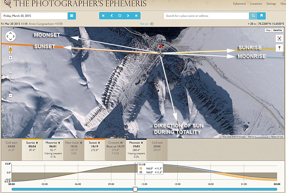
This diagram below from The Photographers Ephemeris and Google shows the direction(azimuth) of the Sun and Moon at rise, set and mid-totality. North is up.  Being so close to the equinox, it's pretty simple, Sun rises almost due east at 6am (local) or 0500UT and sets almost due west at 6pm local or 17:00UT. The background google photo was not taken on eclipse date or at eclipse time. The shadow direction indicates the photo was taken later in the day so the shadows and sunlit areas should not be used to select observing location but they give an indication of the problem caused by the mountains.  Stay near the coastal road, well away from the mountains and west of the bridge and waterway and you should be fine. From this area, the mountains raise the horizon 5-6o above the ideal horizon. Sun's altitude at mid-eclipse is 11 degrees.


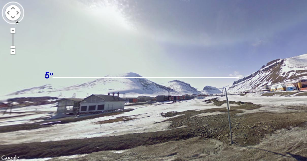
The photo below is from google earth shows the southern horizon as seen from the town near the airport road.  Taking measurements from Google Earth, I've determined that observing from the waterfront, the 300-400m high mountains are 3-4 km away and therefore the mountaintops are about 5-6 degrees high from this location.  The eclipse altitude is only 11 -12 degrees altitude.  So an observer positioned 1.5km south of the waterfront and 1.5km towards those mountains could have totality just blocked by mountaintops or will need to position themselves so that the sun is between mountain peaks.  However it isn't this simple because distances to the mountains vary.  The ridge runs NE-SW and some of the peaks are much closer to the town.  


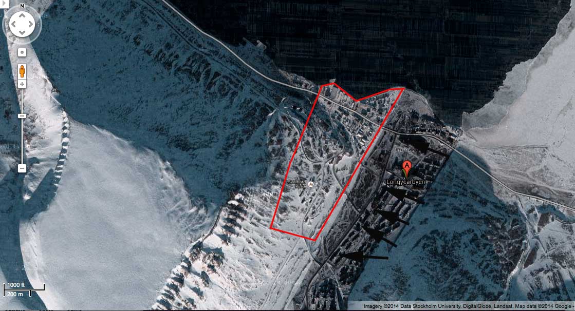
Studying the shadow directions, the Google Maps Satellite image below was probably taken about an hour after eclipse time. Using a combination of Google Earth to examine terrain, Google Maps and The Photographers ephemeris, I have used Photoshop to draw a shadow translating the real shadow in the direction of the black arrows and created artificial shade and drawn in the red area which should be a safe area from which to observe without mountain obscuration except obviously from behind the small ridge in the NW corner.  

Naturally,  you should survey any site the day before during eclipse time to ensure its suitability or take the advice of someone who has surveyed.  


After making the above map, I discovered someone has already done this.  

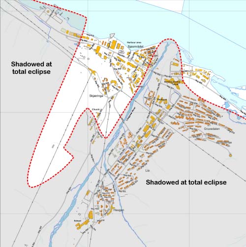
Jay Anderson while on a scouting trip for Travel Quest made a map of Longyearbyen showing parts of the town where the sun will be obscured by the mountains. Jay also provides
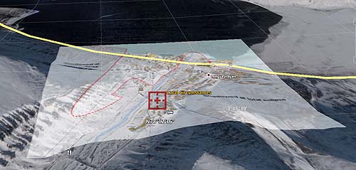
a topographic map of Longyearbyen on his site.  I have taken Jay's maps and fitted them over the landscape in Google Earth to produce these two kmz files.  

LONGYEARBYEN TOPOGRAPHIC LAYER  

I have wrapped the topographic map onto a Google Earth layer. The net result is a switchable layer with contour lines for the terrain.
The fit isn't perfect, so I have tried to make the best fit around Longyearbyen even if it isn't so good further afield.


DOWNLOAD LONGYEARBYEN SUN VISIBILITY AT TOTALITY LAYER
The yellow patch shown where sun light or should I say coronal light will fall during the eclipse.  
Outside the shaded area, the mountains may interfere with observations at totality.  Jay Anderson
produced the shadow map I used to make this by direct observation and photographs during a
scouting trip he made on March 20, 2013.  


Jay Anderson's original shadow map. A large version of this as a plain image can be downloaded here, or on the 2015 TSE section of Jay Anderson's web site.


I have turned Jay's map into a Google Earth layer and wrapped it onto the terrain.


DOWNLOAD GOOGLE EARTH LONGYEARBYEN TOWN ROAD MAP WITH SUN VISIBILITY


Introduction Sun/ Moon
Rise/ Set & Twilight 
Solar Altitude
and Azimuth
on Eclipse Day
Orientation- corona
Sun's axis
EQ mount alignment
Sky at totality  Photographic Information Power & Batteries Further reading